.svg)


These drainage class 9 notes are very simple and easy to understand if approached with the right strategy. Students can grasp the key concepts without any stress, and Educart is here to support you every step of the way!
The NCERT Geography chapter Drainage teaches us about the river systems in India, how they are formed, where they flow, and why they matter so much. From the mighty Himalayan rivers to the seasonal Peninsular rivers, you’ll learn how water moves across the country and helps in farming, power generation, and daily life.
Class 9 Drainage Notes PDF
These study class 9 geography chapter 3 notes based on cbse class 9 sst syllabus will make you grasp the chapter at once with simple language, easy examples, and no jargon. Ideal for last-minute revision prior to exams!


What is Drainage?
The term drainage describes the river system of an area. Look at the physical map. You will notice that small streams flowing from different directions come together to form the main river, which ultimately drains into a large water body such as a lake or a sea or an ocean.
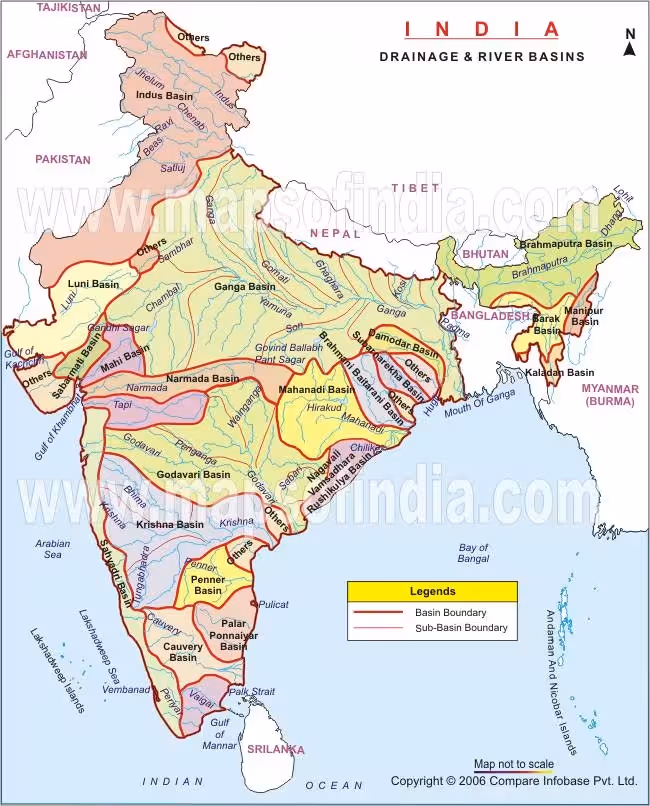
Drainage Basin and Water Divide
A drainage basin, also known as a river basin, is the area of land where all the water from precipitation (rain, snow, etc.) drains into a single point, such as a river, lake, or ocean. It's essentially the entire area that contributes water to a specific river system
Water Divide
It refers to any elevated area, such as a mountain or an upland, which separates two drainage basins known as water divide; for example, the water divide between the Indus and the Ganga river systems.
Drainage Patterns in India
The main drainage patterns formed by rivers are:
- Dendritic: This drainage system is formed when the river channel follows the slope of the terrain. Because many tributaries join the main river, this drainage system appears like the branches of trees.
- Trellis: The trellis pattern is developed when many tributaries join the main river at right angles and the hard and the soft rock exist parallel to each other.
- Rectangular: This develops on strongly jointed rocky terrain that is resistant to erosion. Such rocks have joints at right angles which can be eroded.
- Radial: When the streams of a river flow in different directions from a central peak or a dome-like structure, the radial drainage pattern is developed.Major Drainage Systems in India.
Exam Tip: A common map-based Q asks you to identify east-flowing vs west-flowing rivers. Practice marking rivers like Narmada, Tapi, Godavari, and Krishna on the map.
The Himalayan Rivers - Indus, Ganga, Brahmaputra
The main Himalayan Rivers are the Indus, Ganga, and Brahmaputra.
The Indus River System
- The river Indus originates near Lake Mansarovar in Tibet. It enters India in the Ladakh district of Jammu and Kashmir.
- With a total length of about 2900 km, the river Indus is one of the longest rivers in the world.
- It has many tributaries such as Zaskar, Nubra, Shyok and Hunza which join it in the Kashmir region.
- The Satluj, Beas, Ravi, Chenab and Jhelum join and flow into the River Indus in Pakistan.
- A little over one-third of the Indus basin lies in India (Ladakh, Jammu & Kashmir, Himachal Pradesh, Punjab), while the rest lies in Pakistan.
- The Indus then flows southwards and drains into the Arabian Sea
Ganga River
- The river Ganga originates from the Gangotri Glacier in the Himalayas. It is joined by Alaknanda at Devprayag in Uttarakhand. It is at Haridwar that the river Ganga emerges from the mountains onto the plains.
- Some tributaries of the river Ganga are the Yamuna, Ghaghara, Gandak and Kosi. • Yamuna is a major tributary of Ganga.
- It originates from the Yamunotri Glacier in the Himalayas and meets the River Ganga at Allahabad.
- Rivers such as the Kosi, Gandak and Ghagra rise in the Himalayas in Nepal. They cause floods in the northern plains almost every year. They enrich the soil and make the region agriculturally very productive during the process.
- Chambal, Betwa and Son are some tributaries of the river Ganga which rise in the peninsular uplands.
- The river Ganga flows till Farakka in West Bengal and divides here. Its distributary Bhagirathi– Hooghly flows through the deltaic plains into the Bay of Bengal.
The Brahmaputra River System
- The river Brahmaputra rises east of the Mansarovar Lake in Tibet. Most of its course lies outside India.
- The River Brahmaputra at Namcha Barwa takes a ‘U’ turn and enters Arunachal Pradesh through a gorge. It is joined by many tributaries such as the Dibang and Lohit to form the River Brahmaputra in Assam, where it is also known as Dihang.
- In India, the river passes through a region of high rainfall, and thus, the volume of water and silt increases.
- The river Brahmaputra makes many riverine islands in Assam. Majuli is the largest riverine island formed by the Brahmaputra. The river shifts its channel frequently.
The Peninsular Rivers - Narmada, Tapi, Godavari and Others
The Western Ghats acts as a main water divide in Peninsular India. Some important peninsular rivers are the Godavari, Mahanadi, Krishna and Kaveri. These rivers make deltas at their mouths. While most rivers drain into the Bay of Bengal, the Narmada and the Tapti drain into the Arabian Sea forming estuaries.
The Narmada Basin
- The river Narmada originates in the Amarkantak Hills in Madhya Pradesh.
- It creates many scenic locations on its way into the Arabian Sea.
- The ‘Marble rocks’ near Jabalpur and the Dhuadhar Falls are some notable locations on its course.
- The basin covers parts of Gujarat and Madhya Pradesh. The tributaries of Narmada are very short.
The Tapti Basin
- The Tapti basin originates in the Satpura ranges in the Betul district of Madhya Pradesh.
- It is much shorter in length compared to River Narmada.
- It flows through Madhya Pradesh, Gujarat and Maharashtra.
Note: Other important west-flowing rivers include the Sabarmati, Mahi, Bharathpuzha and Periyar.
The Godavari Basin
- The River Godavari is the largest of all peninsular rivers.
- It originates from the slopes of the Western Ghats in the Nasik district of Maharashtra.
- Its length is about 1500 km, and it drains into the Bay of Bengal.
Role of Rivers in the Economy
- Rivers have been of extreme importance throughout human history. Many civilisations developed on the banks of rivers.
- River water is used for domestic and industrial consumption.
- River water is used for irrigation and navigation.
- River water is used for the generation of electricity.
River Pollution
These are some ways how today our rivers are being polluted on a regular basis.
- Domestic, municipal, and industrial wastes pollute river waters.
- Untreated sewage wastes and industrial effluents also pollute river water.
- This not only reduces the quality of water but also the self-cleansing mechanism of river water.
- Increasing urbanisation has also polluted river water.
Conclusion
The Drainage chapter helps us understand India’s river systems and their significance. With the help of these simplified notes, you can easily revise key points like types of rivers, major river basins, and their features.
Remember, quick revision using sst sample papers and concept clarity are the keys to scoring well. So make sure to go through these notes a couple of times before your test.
Keep learning with Educart, our smart revision partner for exam success!
FAQs
Q1. What is drainage?
Ans. Drainage is the natural network of rivers and streams that take water from higher to lower ground and ultimately to the sea, lake, or any water body.
Q2. What are the two major river systems of India?
Ans. The two major river systems of India are–The Himalayan Rivers (such as Ganga, Yamuna, Brahmaputra) – they flow all the year round, and The Peninsular Rivers (such as Godavari, Krishna, Narmada) – predominantly seasonal.
Q3. Why are the Himalayan rivers perennial rivers?
Ans. Because they remain full of water all year round, since they are supplied by rain as well as melting snow in the mountains.
Q4. What is a river basin?
Ans. A river basin is the land drained by a river and its tributaries. Imagine a large bowl catching all the rainwater flowing towards the main river.
Q5. What is the difference between a distributary and a tributary?
Ans. A tributary is a small river that flows into a large river, while a distributary is a stream of a river that moves away from the main river, typically close to the mouth.
Q6. Why is the Ganga significant to India?
Ans. The Ganga is significant as it sustains millions of people, supplies water for agriculture, and is religiously holy in Indian society.
Q7. What is a delta? Which large river creates a delta in India?
Ans. A delta is a triangular region that develops at the mouth of a river through silt deposits. The Ganga-Brahmaputra creates the largest delta in the world – the Sundarbans Delta.