.svg)


India: Size and Location is the first chapter of Class 9 Geography (Contemporary India – I). This chapter gives students a foundational understanding of India's geographical position, its size relative to other countries, latitudinal and longitudinal extent, and its neighbouring nations. Learning these basics helps students understand how India's location influences its climate, culture, and strategic importance. Today, we are sharing Class 9 Geography Notes Chapter 1 – India: Size and Location in a clear, sequence-wise manner to make learning simple and interesting. Click here for the complete CBSE Class 9 SST Syllabus.
Class 9 Geography Notes Chapter 1 – India: Size and Location
We provide the best-quality notes for all subjects so that students can revise quickly during exams and tests. These notes help you plan an effective revision strategy in a short time. You can download them from below:


1. India: Size and Location - Introduction
This chapter introduces students to India's geographical identity - where it is located, how large it is, and what makes its position on the world map significant. Once you understand these basics, this chapter becomes one of the most straightforward and scoring chapters in Class 9 Social Science Geography.
2. India's Location
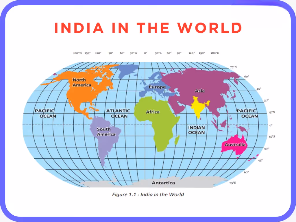
India is located in the northern hemisphere, in the southern part of Asia. It lies entirely in the Eastern Hemisphere. India's position on the globe is what influences its climate, time zone, and connection with the rest of the world.
- India's latitudinal extent is from 8°4'N to 37°6'N
- India's longitudinal extent is from 68°7'E to 97°25'E
- The Tropic of Cancer (23°30'N) passes almost through the middle of India, dividing it into two nearly equal halves
- The Standard Meridian of India is 82°30'E, which passes through Mirzapur (Uttar Pradesh)
These coordinates are important for map-based questions in exams. The large latitudinal and longitudinal extent of India results in a wide variety of climates, time differences between the east and west, and diverse physical features across the country.
3. India's Size
India is the 7th largest country in the world by area. Its large size is one of the main reasons for the diversity found in its physical features, climate, culture, and natural resources.
- Total area of India: approximately 3.28 million square kilometres
- India accounts for about 2.4% of the total geographical area of the world
- India has a land boundary of approximately 15,200 km
- The total length of the coastline (including islands) is approximately 7,516.6 km
- From north to south, India extends about 3,214 km
- From east to west, India extends about 2,933 km
This vast size means that the sun rises almost 2 hours earlier in the east (Arunachal Pradesh) compared to the west (Gujarat). That is why India follows a single Standard Time based on the 82°30'E meridian to avoid confusion across regions.
4. India and the World
India's position at the centre of Asia, surrounded by oceans on three sides, has made it an important country in both ancient and modern times. It has always served as a natural connecting point between the eastern and western parts of the world.
- India is surrounded by the Himalayan ranges in the north, which separate it from Central and East Asia
- The Indian Ocean, Arabian Sea and Bay of Bengal surround India on three sides
- India's central location between the East and West makes it a natural hub for trade and cultural exchange
- India is the only country after which an entire ocean (the Indian Ocean) is named, which reflects its historical maritime importance
This unique positioning has allowed India to maintain strong trade and cultural ties with countries in Europe, Africa, Southeast Asia, and the Middle East. Even today, major international shipping routes pass through the Indian Ocean, giving India a strategic advantage in global trade.
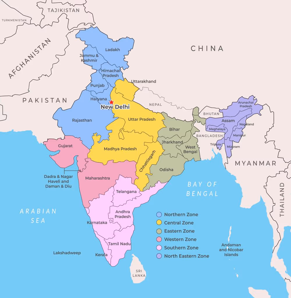
5. India's Neighbours
India shares its borders with several countries, which makes its foreign relations and geographical position very important in South Asia. Knowledge of India's neighbours is also frequently tested in map-based exam questions.
India shares its land boundaries with 7 countries and maritime borders with 2 countries.
Land Neighbours: Pakistan and Afghanistan (northwest), China, Nepal and Bhutan (north), Bangladesh and Myanmar (east)
Maritime Neighbours: Sri Lanka (separated by the Palk Strait) and Maldives (in the Indian Ocean)
India's relationship with its neighbours has a direct impact on its trade, security, and foreign policy. While some borders are peaceful and open, others have been subject to historical disputes and tensions. The island of Sri Lanka is separated from India by a narrow channel of sea formed by the Palk Strait and the Gulf of Mannar.
6. Importance of India's Location
A country's location plays a major role in shaping its history, economy, and culture. India's geographical position has given it several natural and strategic advantages over centuries.
- Trade Routes: The ancient sea routes passing through the Indian Ocean made India a centre of international trade. Indian spices, cotton and silk were traded across the world.
- Cultural Exchange: India's central position allowed it to receive and share cultural, religious and scientific ideas with civilizations in Europe, Africa and Southeast Asia.
- Strategic Importance: India's location in South Asia allows it to maintain strong ties with neighbouring countries and play a key role in regional diplomacy.
- Climate: The Tropic of Cancer passing through India gives it a tropical climate in the south and a sub-tropical climate in the north, resulting in diverse weather and vegetation.
India's access to three major water bodies also gives it control over important sea lanes, which remains a key factor in its trade and defence strategies even today.
7. India's Landmass and Boundaries
India's boundaries are formed by a combination of natural features such as mountains and seas, as well as political boundaries shared with neighbouring countries. India shares borders with many different physical features that define its boundaries on each side.
- North: The Himalayas, Karakoram and Hindu Kush mountain ranges form a natural barrier
- Northwest: Pakistan and the Thar Desert
- Northeast: The hills and forests bordering Myanmar and Bangladesh
- South: The Deccan Peninsula extends into the Indian Ocean, ending at Cape Comorin (Kanyakumari), the southernmost tip of mainland India
- Andaman and Nicobar Islands lie in the Bay of Bengal, while Lakshadweep Islands lie in the Arabian Sea - both are part of India's territory
The Himalayan ranges in the north have historically protected India from cold winds and external invasions, while the long coastline has kept India connected to the rest of the world through sea trade and travel.
8. Key Terms to Remember
Students must remember the following important terms from this chapter.
- Latitude: Angular distance of a place north or south of the Equator
- Longitude: Angular distance of a place east or west of the Prime Meridian
- Standard Meridian: The meridian used for a country's standard time (India: 82°30'E)
- Tropic of Cancer: The latitude at 23°30'N, which divides India into roughly two halves
- Palk Strait: The narrow sea channel between India and Sri Lanka
- Subcontinent: A large landmass that is part of a continent but is geographically distinct - India forms the Indian Subcontinent
The chapter India: Size and Location Class 9 gives students a clear picture of where India stands in the world, how vast and diverse its geography is, and why its location has been important throughout history. These quick revision notes will help you revise the entire chapter in just a few minutes without opening the textbook. With clear concepts, examples and structured answers, you can easily score well in exams.
FAQs
Q1. What is the latitudinal and longitudinal extent of India?
Ans. India's latitudinal extent is from 8°4'N to 37°6'N and its longitudinal extent is from 68°7'E to 97°25'E.
Q2. Which line passes through the middle of India?
Ans. The Tropic of Cancer (23°30'N) passes almost through the middle of India, dividing it into two nearly equal halves.
Q3. What is the Standard Meridian of India and why is it important?
Ans. The Standard Meridian of India is 82°30'E. It passes through Mirzapur in Uttar Pradesh and is used to determine Indian Standard Time (IST).
Q4. How many countries share land boundaries with India?
Ans. India shares land boundaries with 7 countries: Pakistan, Afghanistan, China, Nepal, Bhutan, Bangladesh and Myanmar.
Q5. Why is India's location considered strategically important?
Ans. India's central location in Asia, along with its access to the Indian Ocean, Arabian Sea and Bay of Bengal, makes it important for international trade and regional diplomacy. It connects the East and the West, giving India significant geopolitical importance.